
South China Geographical Journal >
Land Use Change and Driving Forces Detection of the Coastal Landscape in the Pearl River Estuary Based on GEE Cloud Platform
Received date: 2023-09-01
Revised date: 2023-09-23
Online published: 2023-12-25
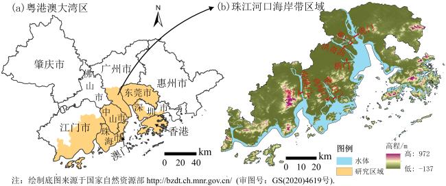
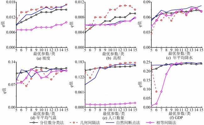
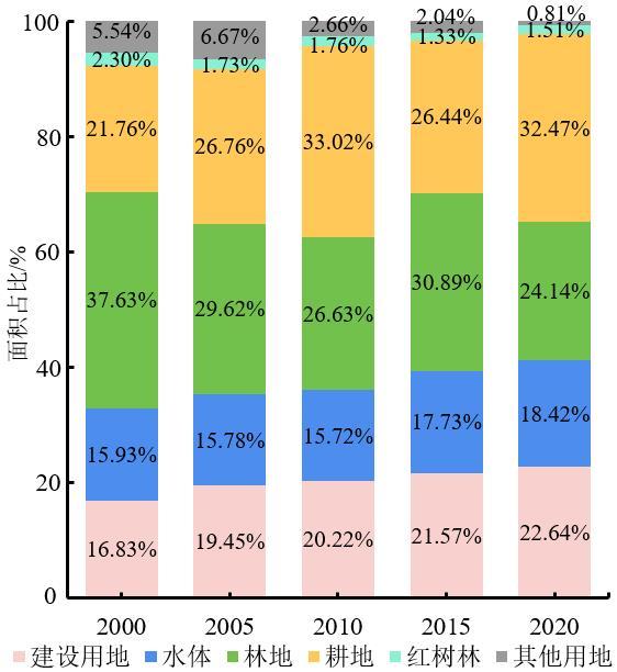
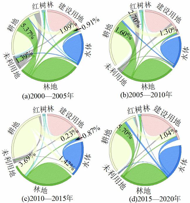
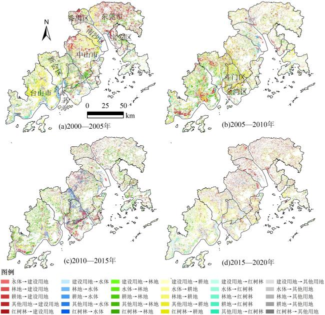
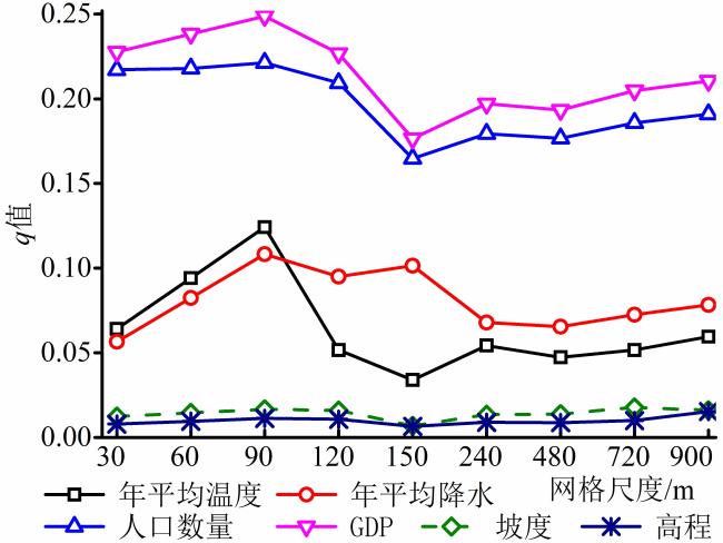
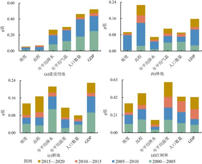
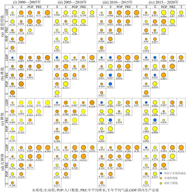
The coast of Pearl River estuary is one of the most densely populated, economically active, and resource-intensive large-scale estuarine coastal zone in China and the world. It is facing many problems such as excessive reclamation, functional degradation, and resource attenuation, which poses a serious threat to regional ecological balance and high-quality development. Due to the limited load of traditional remote sensing processing platform, the consistency of image processing in medium and large scale areas is poor, resulting in low accuracy of ground object classification results. Based on the Google Earth Engine(GEE) cloud platform, five periods of land use type data were obtained from 2000 to 2020, with the total accuracy ranging from 86.27% to 90.15%. Secondly, land use transfer matrix and dynamic degree are used to describe the temporal and spatial characteristics of land use transition in the coast of Pearl River Estuary. Finally, the influence mechanism of landscape evolution in the Pearl River Estuary is quantitatively revealed by using the optimal parameter geographic detector the geographic detector. The results are as follows: (1) The coastal landscape pattern of the Pearl River Estuary altered frequently over the past twenty years, with the comprehensive dynamic degree ranging from 2.66% to 3.62%. The dramatically shift between forest and cultivated land was observed in the western coast of the Pearl River Estuary, while the strong growth of construction land was mainly detected in the eastern coast of the Pearl River Estuary. (2) The optimal parameters of geographic detection of coastal landscape evolution in the Pearl River Estuary could be divided into 9~15 categories, and the optimal spatial scale threshold of geographical detection of impact factors was 90 m×90 m. (3) The coastal landscape evolution pattern of the Pearl River Estuary suffered from both natural and anthropogenic factors at different periods. The driving force of the two-factor interaction was significantly higher than that of the single-factor driving force, showing a two-factor enhancement effect or nonlinear enhancement. And the interaction between GDP variation and temperature variation, with a q value of 0.345, contributed the most to the change of mangrove forest from 2000 to 2005. The study revealed that future resource planning and utilization and comprehensive management of the Pearl River Estuary coastal zone should be paid enough attention to the scale effect of landscape patches. In addition, quantitative detection of interaction between GDP and other factors was in the primary determinants of land use change. To balance the coordination relationship between the rapid economic growth and the regional ecological environment, and promote the high-quality development of the Guangdong-Hong Kong-Macao Greater Bay Area.
CHEN Kanglin , CHEN Sikai , GONG Jianzhou . Land Use Change and Driving Forces Detection of the Coastal Landscape in the Pearl River Estuary Based on GEE Cloud Platform[J]. South China Geographical Journal, 2023 , 1(3) : 10 -24 . DOI: 10.20125/j.2097-2245.202303002
表1 2000—2020年珠江口沿岸土地利用分类的用户精度、总体精度和Kappa系数Tab.1 User accuracy, total accuracy and Kappa coefficients of landscape classification in the Pearl River Estuary from 2000 to 2020 |
| 精度 | 2000 | 2005 | 2010 | 2015 | 2020 | |
|---|---|---|---|---|---|---|
| 用户精度/% | 建设用地 | 87.00 | 88.00 | 89.00 | 90.67 | 91.33 |
| 水体 | 90.00 | 91.33 | 91.67 | 92.33 | 92.67 | |
| 林地 | 89.33 | 90.33 | 90.67 | 91.67 | 92.00 | |
| 耕地 | 85.00 | 86.33 | 87.00 | 88.67 | 89.67 | |
| 红树林 | 84.00 | 85.67 | 86.33 | 87.67 | 88.67 | |
| 其他用地 | 82.33 | 84.33 | 84.67 | 86.33 | 86.67 | |
| 总体精度/% | 86.27 | 87.66 | 88.22 | 89.56 | 90.15 | |
| Kappa系数 | 0.852 | 0.864 | 0.875 | 0.889 | 0.897 | |
表2 影响因素信息Tab.2 Influence factors of the land use change in this study |
| 数据名称 | 格式 | 数据来源 |
|---|---|---|
| 高程 | 栅格数据(30 m) | 中国科学院计算机网络信息中心地理空间数据云平台(http://www.gscloud.cn) |
| 坡度 | 栅格数据(30 m) | 在ArcGIS中对高程数据进行坡度分析,从而获取坡度数据 |
| 年平均气温 | 栅格数据(1 km) | 国家青藏高原科学数据中心(http://data.tpdc.ac.cn) |
| 年平均降水量 | 栅格数据(1 km) | 国家青藏高原科学数据中心(http://data.tpdc.ac.cn) |
| 人口数量 | 栅格数据(1 km) | 中国人口空间分布公里网格数据集,资源环境科学数据注册与出版系统(http://www.resdc.cn) |
| GDP | 栅格数据(1 km) | 中国GDP空间分布公里网格数据集,资源环境科学数据注册与出版系统(http://www.resdc.cn) |
|
表3 因子交互作用类型Tab.3 Types of influence factors interaction |
| 判据 | 交互作用 |
|---|---|
| q(X 1∩X 2) < min(q(X 1), q(X 2)) | 非线性减弱 |
| min(q(X 1), q(X 2)) < q(X 1∩X 2) < max(q(X 1), q(X 2)) | 单因子非线性减弱 |
| q(X 1∩X 2) > max(q(X 1), q(X 2)) | 双因子增强 |
| q(X 1∩X 2) = q(X 1) + q(X 2) | 独立 |
| q(X 1∩X 2) > q(X 1) + q(X 2) | 非线性增强 |
表4 2000—2020年珠江河口沿岸各期土地利用变化动态度 (%)Tab.4 Dynamic degree of land use change in the coast of the Pearl River Estuary from 2000 to 2020 |
| 土地利用类型 | 2000—2005年 | 2005—2010年 | 2010—2015年 | 2015—2020年 |
|---|---|---|---|---|
| 综合动态度 | 3.62 | 3.28 | 3.16 | 2.66 |
| 建设用地 | 3.10 | 0.79 | 1.26 | 1.06 |
| 水体 | -0.19 | -0.08 | 2.49 | 0.85 |
| 林地 | -4.26 | -2.02 | 3.12 | -4.31 |
| 耕地 | 4.59 | 4.68 | -4.05 | 4.65 |
| 其它用地 | 4.07 | -12.04 | -4.69 | -12.01 |
| 红树林 | -5.01 | 0.35 | -4.95 | 2.84 |
| 1 |
陈吉余, 陈沈良. 中国河口海岸面临的挑战[J]. 海洋地质动态, 2002(1):1-5.
|
| 2 |
|
| 3 |
|
| 4 |
Wetlands. Wetlands International[EB/OL]. 2023/2023-04-23.
|
| 5 |
|
| 6 |
|
| 7 |
梁向阳, 梁家海, 萧金文. 珠江三角洲海岸变迁及对城市可持续发展的影响[J]. 资源调查与环境, 2005, 64(4):283-291.
|
| 8 |
徐庆勇, 黄玫, 刘洪升, 等. 基于RS和GIS的珠江三角洲生态环境脆弱性综合评价[J]. 应用生态学报, 2011, 22(11):2987-2995.
|
| 9 |
王琎, 吴志峰, 李少英, 等. 珠江口湾区海岸线及沿岸土地利用变化遥感监测与分析[J]. 地理科学, 2016, 36(12):1903-1911.
|
| 10 |
|
| 11 |
崔伟中. 珠江河口滩涂湿地的问题及其保护研究[J]. 湿地科学, 2004(1):26-30.
|
| 12 |
|
| 13 |
徐婷婷, 郑锐滨, 陈龙, 等. 粤港澳大湾区海岸线时空变化及驱动力分析[J]. 环境生态学, 2022, 4(11):34-42.
|
| 14 |
|
| 15 |
王树功. 珠江河口区典型湿地景观演变及调控研究[D]. 广州: 中山大学, 2005,05.
|
| 16 |
鞠洪润, 张生瑞, 闫逸晨. 1980—2020年粤港澳大湾区城镇用地空间格局类型演变及其驱动力多维探测[J]. 地理学报, 2022, 77(5):1086-1101.
|
| 17 |
韩宇韬. 数字正射影像镶嵌中色彩一致性处理的若干问题研究[D]. 武汉: 武汉大学, 2014.
|
| 18 |
基于最佳路径的遥感影像色彩一致性处理方法[P]. 中国专利: CN113781587A, 2021.
|
| 19 |
闫小培, 毛蒋兴, 普军. 巨型城市区域土地利用变化的人文因素分析——以珠江三角洲地区为例[J]. 地理学报, 2006, 61(6):613-623.
|
| 20 |
宗玮. 上海海岸带土地利用/覆盖格局变化及驱动机制研究[D]. 上海: 华东师范大学, 2012.
|
| 21 |
|
| 22 |
程林, 田海兰, 武爱彬, 等. 近四十年来冀津海岸带土地利用时空变化及驱动因素[J]. 海洋科学, 2021, 45(6):135-146.
|
| 23 |
杨晨晨, 甘华阳, 万荣胜, 等. 粤港澳大湾区1975—2018年海岸线时空演变与影响因素分析[J]. 中国地质, 2021, 48(3):697-707.
|
| 24 |
王海军, 张彬, 刘耀林, 等. 基于重心-GTWR模型的京津冀城市群城镇扩展格局与驱动力多维解析[J]. 地理学报, 2018, 73(6):1076-1092.
|
| 25 |
张廷靖. 黄河三角洲生态系统服务时空动态及驱动机制研究[D]. 济南: 山东大学, 2022.
|
| 26 |
王劲峰, 徐成东. 地理探测器:原理与展望[J]. 地理学报, 2017, 72(1):116-134.
|
| 27 |
张华玉, 秦年秀, 汪军能, 等. 广西海岸带土地利用时空格局及其驱动因子[J]. 水土保持研究, 2022, 29(3):367-374.
|
| 28 |
陈玉福, 董鸣. 生态学系统的空间异质性[J]. 生态学报, 2003, 23(2):346-352.
|
| 29 |
龚建周, 夏北成, 李楠. 广州市土地覆被格局异质性的尺度与等级特征[J]. 地理学报, 2006, 61(8):873-881.
|
| 30 |
|
| 31 |
广东省统计局. 广东统计年鉴2022[M]. 北京: 中国统计出版社, 2022: 45-46.
|
| 32 |
胡盼盼, 李锋, 胡聃, 等. 1980—2015年珠三角城市群城市扩张的时空特征分析[J]. 生态学报, 2021, 41(17):7063-7072.
|
| 33 |
易阿岚, 王钧. 上海市湿地景观格局时空演变与驱动机制的量化研究[J]. 生态学报, 2021, 41(7):2622-2631.
|
| 34 |
王秀兰, 包玉海. 土地利用动态变化研究方法探讨[J]. 地理科学进展, 1999(1):83-89.
|
| 35 |
王思远, 刘纪远, 张增祥, 等. 中国土地利用时空特征分析[J]. 地理学报, 2001(6):631-639.
|
| 36 |
|
| 37 |
王春晓, 黄舒语, 苗菁, 等. 珠三角基塘景观格局演变特征及驱动因素研究——以佛山顺德区为例[J]. 中国园林, 2022, 38(6):75-80.
|
| 38 |
叶林, 宋星洲. 粤港澳大湾区区域协同创新系统: 基于规划纲要的视角[J]. 行政论坛, 2019, 15(3):87-94.
|
| 39 |
汪以洋, 任红伟, 邵帅, 等. 打造“对口帮扶+合作共赢”的“广东样本”——深圳全面对口帮扶汕尾的主要做法与启示[J]. 广东经济, 2016(12):26-29.
|
| 40 |
桂花. 广东产业与劳动力双转移: 现状、问题和趋势[J]. 现代企业, 2010(3):39-40.
|
| 41 |
彭芳梅. 《粤港澳大湾区发展规划纲要》解读与启示[J]. 特区实践与理论, 2019(2):78-82.
|
| 42 |
吕志强, 文雅, 孙琤, 等. 珠江口沿岸土地利用变化及其地表热环境遥感分析[J]. 生态环境学报, 2010, 19(8):1771-1777.
|
| 43 |
余富祥, 胡月明, 刘振杰, 等. 基于力学平衡模型的耕地多功能演变及其协调性分析——以珠江三角洲为例[J]. 农业资源与环境学报, 2019, 36(6):728-737.
|
| 44 |
|
| 45 |
|
| 46 |
孙晓宇, 苏奋振, 吕婷婷, 等. 珠江口西岸土地利用景观格局变化及驱动力分析[J]. 地球信息科学学报, 2009, 11(4):436-441.
|
| 47 |
广东省人民政府. 广东省国民经济和社会发展第十个五年计划纲要[Z]. 广东省人民政府办公厅, 2001: 8-15.
|
| 48 |
广东省人民政府. 广东国民经济和社会发展第十一个五年规划纲要[Z]. 广东省人民政府办公厅, 2006: 3-12.
|
/
| 〈 |
|
〉 |