
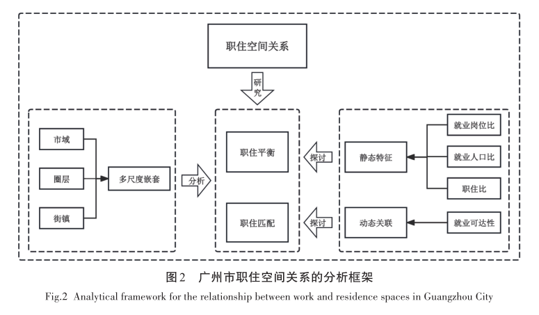
In China, high-grade service and high-tech companies have gradually replaced traditional industries in city centers, forcing the latter to move to the outskirts. While original residential areas persist in the inner city, new migrants, the primary workforce in newer sectors, largely reside in the suburbs due to lower housing costs. Such spatial imbalance and jobs-housing mismatch in Chinese cities have attracted significant academic attention. This research uses Guangzhou as a study area constructing a three-scale of “City Region-Rings-Streets/Towns” analytical framework with “static characteristics-dynamic correlation” to analyze the job-housing spatial relationship. It applies a mixed-methods approach combining qualitative and quantitative methods with GIS spatial analysis, including the job-housing ratio, an employment accessibility model, and GIS hotspot analysis to explore the changing spatial patterns of job-housing disparity in the study area. It reveals that the outcomes of job-housing spatial differentiation vary across different scales. The overall level of job-housing spatial balance remains relatively low because of the distribution of employment opportunities. The overall job-housing match rate exhibits a decreasing gradient from the urban core to the inner suburbs and then to the outer suburbs, with significant spatial disparities in its distribution. There is a high employment accessibility in some streets and towns within both the inner and outer suburbs. A balanced job-housing relationship in which jobs outnumber housing units exists in most streets and towns within the inner city and select inner suburbs, while a significant spatial mismatch characterizes other areas. This research systematically examines the patterns and matching relationship between job supply and demand, as well as job-housing spaces in a megacity. It thereby fills a gap in academic research on the integrated dual-dimensional study of urban job-housing balance and mismatch in China. Ultimately, the research provides valuable insights for promoting high-quality urban development and the rational planning of future workplace and residential spaces in Chinese cities.
The rapid development of the Guangdong-Hong Kong-Macao Greater Bay Area has led to significant changes in land use patterns, which have far-reaching impacts on the regional ecology, economy, and social structure. In order to deeply understand these changes and formulate scientific and reasonable land management policies, based on a total of 31 periods of land use data from 1990 to 2020, adopts a method combining K-means and a convolutional neural network (CNN). Firstly, K-means is used to preliminarily classify land use data and provide accurate training labels. Secondly, a convolutional neural network is used to extract and classify features to achieve high-precision land use identification. Finally, the classification results and land use dynamic degree are integrated to quantitatively analyze the characteristics of land use change in the study area. The results show that: (1) The optimal effect is obtained when the land use data is divided into four categories. The silhouette coefficient for K-means is 0.73, and the classification accuracy of the convolutional neural network is 89.71%, fully verifying the effectiveness of this method. (2) In the past 30 years, the land use change in the study area can be divided into four typical stages, namely, the initial stage of rapid urbanization (1990—1997), the acceleration urbanization period (1998—2004), the stable development period (2005—2009), and the optimization and sustainable development period (2010—2020). Significant differences in land use patterns exist across these stages. (3) The characteristics of land use change in the study area are mainly reflected in the continuous reduction of farmland area, the rapid expansion of urban and construction land, while ecological land such as forests and water bodies, although remaining relatively stable, also face certain pressures and challenges. The study emphasizes the innovative application of machine learning technology in land use research, noting that the method can effectively identify land use pattern changes under limited labeled data, demonstrating its significant value in complex classification research. The research results not only deepen the understanding of land use change in the Guangdong-Hong Kong-Macao Greater Bay Area, but also deepen the understanding of land use change in the Guangdong-Hong Kong-Macao Greater Bay Area. Moreover, it provides a scientific basis and practical guidance for regional land use planning, management and sustainable development, which is of great significance for promoting regional coordinated development.
Considering the urgent need to construct a new pattern of Chinese-style urbanization development in Guangdong Province, this study, based on urban land use data and statistical panel data from 122 districts and counties in Guangdong Province from 2000 to 2020, this study establishes a quantitative model to analyze the spatiotemporal differentiation characteristics of urban land expansion. It further integrates the Optimal Parameter Geographical Detector (OPGD) and the Geospatial Convergent Cross Mapping (GCCM) model to investigate the driving mechanisms and corresponding optimization pathways of urban land expansion. The results show that: (1) From 2000 to 2020, the total urban land area in Guangdong Province continued to expand, increasing by 7.53%. The Pearl River Delta region experienced the most significant growth, exhibiting a spatial pattern with the Pearl River Delta region as the center, where urban land expansion gradually weakened towards the periphery. (2) The OPGD results reveal that the intensity change of urban land expansion is a result of multi-factor interactions. The explanatory power of two-factor interactions (64.2%-85.7%) is significantly higher than that of single factors. (3) The GCCM results indicate a significant bidirectional causal relationship between per capita GDP and urban land expansion intensity during the study period, suggesting a mutual driving effect. The model also identifies per capita GDP as the strongest predictor of urban land expansion intensity. Furthermore, analyses of causality among urban land expansion intensity, population urbanization, road network density, and the Remote Sensing-based Ecological Index (RSEI) show that urban land expansion drives population urbanization, while transportation networks and the ecological environment are also causal factors promoting urban land expansion. Therefore, in the future development process, how to simultaneously improve the quality of urbanization and promote urban-rural integration has become a key issue.
This study focuses on 57 county-level administrative units in Guangdong Province, using flow network analysis and system coordination coupling degree research methods to calculate the coupling degree between the transportation and economic systems, and explore the coordination relationship between factor flows and economic development. Research has found that: (1) The internal county-level units surrounded by Huizhou, Heyuan and Jieyang, as well as the internal county-level units of Zhanjiang City, form two relatively independent high-intensity traffic flow subgroups, which have a strong radiation effect on the traffic flow of surrounding county-level units. (2) There are 15 county-level units with coordinated traffic flow and economic development, 33 county-level units on the brink of imbalance or with slight imbalance, and 8 county-level units with severe imbalance. (3) The coupling coordination degree of traffic flow and economic development exhibits spatial heterogeneity. The coupling coordination degree of county-level units in the Pearl River Delta is relatively good, with economic development and traffic flow development promoting each other; while the coupling coordination degree of county-level units in eastern, western, and northern Guangdong is relatively low, and there is a certain degree of disorder between economic development and transportation system development. The article proposes differentiated transportation optimization strategies and suggestions to improve the long-term guarantee mechanism for county-level finance, thereby promoting high-quality economic development at the county level.
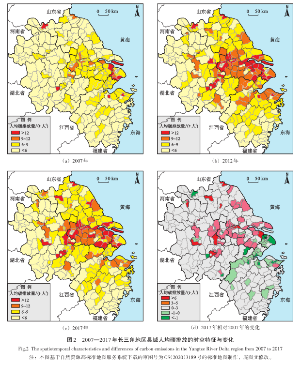
To explore the impacts of green technology innovation and environmental policies on regional carbon emissions as well as their scale effects, this study employs a panel data sample of 306 county-level units in the Yangtze River Delta region from 2007 to 2017. A fixed-effects model is applied to analyze the effects of green technology innovation and environmental policies on regional carbon emissions, while quantile regression is used to examine the differential impacts of green technologies at different scales and environmental policies at varying levels. The findings indicate that: (1) The carbon emission intensity in the Yangtze River Delta region shows a development trend of first increasing and then decreasing, and the regional gap has significantly reduced. (2) The carbon emissions of counties in the Yangtze River Delta region have a clear “core-periphery” structure, with regions with high carbon emissions concentrated in the Z-shaped urban belt of Hefei, Nanjing, Shanghai, Hangzhou, and Ningbo. (3) The scale of green technology in the Yangtze River Delta region continues to rise, with local technology occupying an absolute position, and the proportion of cross-region co-patents steadily increasing. The rules of hierarchical diffusion, geographical proximity, and strong ties play an important role in the cross-region green technology cooperation networks. (4) The improvement of local green technology has led to more carbon emissions, and cross-region cooperation in green technology has reduced regional carbon emission intensity. Provincial and urban-level environmental policies have almost no impact on regional carbon emissions, while county-level policies have a significant limiting effect; the larger the scale, the weaker the policy effectiveness. The Yangtze River Delta regions should continue to strengthen green technology transfer and cross-region cooperation, continuously amplify the spillover effects of technology and the attributes of public goods, and promote green technology innovation to empower carbon reduction. At the same time, focusing on county-level units, formulating environmental policies that are more in line with regional realities to better leverage the hard constraints of policies.
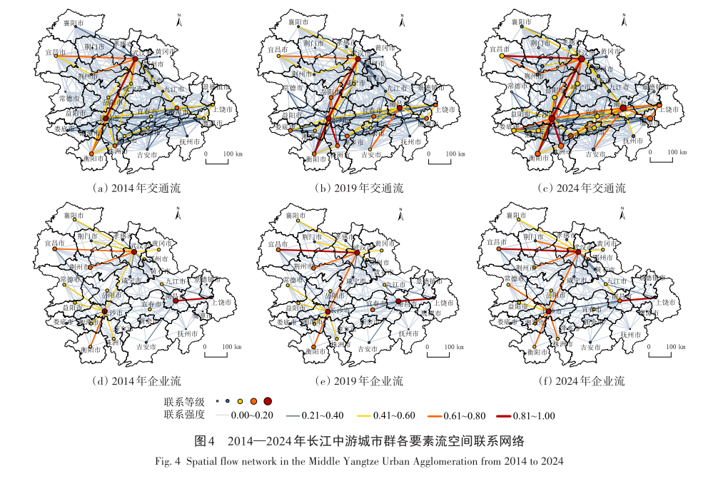
To reveal the spatial pattern and coordination mechanisms of urban multi-element flow networks, this paper constructs urban transportation, enterprise, and information flow networks in the urban agglomeration of the middle reaches of the Yangtze River based on train schedules, branch offices of listed companies, and Baidu index data. The study employs social network analysis, entropy method, coupling coordination degree model, and QAP analysis to explore the evolution characteristics of the urban network structure in the middle reaches of the Yangtze River from 2014 to 2024. The results indicate that: (1) In terms of network topology, the transportation network tends toward balanced optimization, the enterprise network shows fluctuation diffusion and secondary agglomeration, and the efficiency and agglomeration of the information network are enhanced. The overall node centrality increases, while the differentiation of betweenness centrality intensifies. (2) In terms of spatial structure, the transportation network forms a “Z”-shaped backbone structure with Wuhan, Changsha, and Nanchang as the core of the “Iron Triangle”. The enterprise network shifts from a dual-core drive to gradient penetration, and the information network forms a structure of long-distance connections and multi-polar coordination. (3) In terms of network relationships, the coupling coordination degree of centrality among the three networks is in a mild state of imbalance. The core-periphery structure is prominent, link coordination continues to improve, and the overall correlation among the three flows continues to strengthen, with significant synergy and radiation effects in the information flow. In conclusion, the current network is overall closely connected, but coordination of element flows is insufficient, and spatial heterogeneity is prominent. Accordingly, it is suggested that network coordination and resilience be enhanced by focusing on the construction of hub systems, restructuring regional development axes, and promoting digital integration.
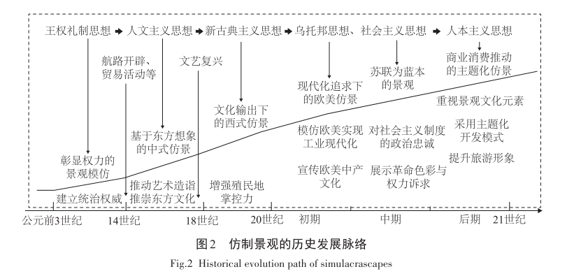
Simulacrascapes are intentionally modeled on foreign or historical prototypes and represent a global phenomenon whose evolution reflects shifting cultural currents, aesthetic movements, and power dynamics. This paper first traces their historical development from BC 3rd to the 21st century and classification, and then adopts a rigorous literature search methodology that combines snowball tracing from key sources, multi‑database keyword retrieval, and expert validation to build a multidimensional critical analysis framework. Our review shows that: (1) The evolution of simulacrascapes is shaped at the community scale residential simulacrascapes serve as symbols through which the aspiring middle class constructs identity; at the urban scale simulacrascapes function as growth machines of modernization and global branding, produced through alliances among governments, developers, new media, and consumers; and at the national scale themed simulacrascapes act as vehicles for dominant ideologies and arenas for power negotiation. (3) From a theoretical perspective, there is an overemphasis on formal reproduction at the expense of local meaning-making; the persistence of colonial narratives, consumerist discourses, and cultural displacement that undermine indigenous identity; and the commodification and staging of simulacrascapes that challenge claims to cultural authenticity. Finally, we outline directions for future research, including how simulacrascapes reshape and govern urban social space, the mechanisms of their spatial production, the interplay between local practices and meanings, the implications of a replication-and-hybridization continuum, and the advancement of theory through place-based case studies.
Guided by the national policy of “integrate where appropriate, and integrate to the fullest extent possible” for the integrated development of culture and tourism, this paper aims to explore the integration mechanism between museums and regional tourism, analyze the spatiotemporal characteristics of their coordinated development, and provide a reference for the planning and policy-making of the national museum tourism industry. Based on data from 31 provinces, autonomous regions, and municipalities directly under the central government (excluding Hong Kong, Macao, and Taiwan) in China from 2010 to 2019, this study employs the coupling coordination model to empirically analyze the coupling coordination degree and spatial correlation between the museum industry and regional tourism development, thereby revealing the evolutionary trends and spatial patterns of the coordination relationship between the two systems. The results show that during the study period, both China’s museum industry and regional tourism were in a growth stage, exhibiting an interrelated development trend. The degree of coordination continuously improved and remained stable at the moderately coordinated coupling stage. However, in terms of spatial distribution, significant regional differentiation exists nationwide. A cross-shaped high-value planar area of coordination degree formed in central and southern China, while the northwestern region remained a development lowland. From a national perspective, the driving effect of the tourism industry is stronger than that of the museum industry; future sluggish growth in tourism will affect the coupling status of the two systems. The coordinated development of museums and regional tourism exhibits clear spatiotemporal evolution characteristics and regional imbalance. Future efforts should focus on industrial collaboration and regional synergy to promote sustainable and high-quality coordination between the museum and tourism sectors nationwide.
With the unceasing progress of urbanization, regional land use has witnessed increasingly drastic alterations, and consequently, the ensuing regional ecological security problems have gradually come to the fore. Taking Anhui Province as a case in point, this paper delves into the characteristics of land use landscape changes by leveraging the land use data of Anhui Province spanning from 2000 to 2020. Sixteen indicators are meticulously distilled from three dimensions, namely the natural environment, social environment, and economic development, to formulate a land ecological security evaluation system tailored to Anhui Province. The comprehensive index method is employed to quantitatively assess the land ecological security status within the province; meanwhile, the obstacle factor model is used to dissect internal influencing factors and pinpoint key obstacle factors, thereby providing a scientific underpinning for regional land ecological protection and sustainable development strategies. The research findings disclose that: (1) during the study period, remarkable transformations took place in the land use pattern of Anhui Province. The conversion rate of cultivated land into construction land progressively accelerated, and the overall landscape fragmentation and complexity also witnessed a significant upsurge; (2) From 2000 to 2020, the overall land ecological security index in Anhui Province fluctuated upward, surging from 0.418 7 in 2000 to 0.536 1 in 2020, and the security level shifted from relatively unsafe to relatively safe; (3) With the fluctuation of the state of land ecological security in Anhui Province, the main obstacle factors affecting ecological security also change, and the factors such as population and tertiary industry have a relatively large degree of influence on ecological security.This study provides empirical references and theoretical support for land ecological security evaluation and sustainable development in Anhui Province, and helps to promote rational planning and management of regional land use.
Software serves as a pivotal medium bridging theoretical knowledge and practical application in the teaching process of quantitative geography, playing a fundamental role in the entire process of achieving teaching objectives, cultivating students' abilities, and facilitating the transition to scientific research. To address the issues in undergraduate quantitative geography education, including the lag in introducing frontier research tools, the disconnect between research and teaching, and the scarcity of research on practical teaching reform from the perspective of software application, this paper explores the application and innovation of Stata software in the practical teaching of quantitative geography. It first introduces the models and methods included in mainstream quantitative geography textbooks, compares the advantages and disadvantages of commonly used software in teaching applications, then presents the characteristics and advantages of Stata software, and sorts out the models and methods that can be implemented by Stata. Subsequently, three reform pathways are proposed, including the dual-track parallel practice model, the extension of teaching from classical models to cutting-edge methods, and the empowerment of practical teaching tools through dynamic document functionality. Finally, the effectiveness of Stata in practical teaching is verified through a case study and a questionnaire survey. The research indicates that Stata is easy to learn and efficient, covering most methods in textbooks. Evidence shows that 78% of students found it easy to use, 86% perceived an improvement in learning outcomes, and 96% considered Stata suitable for practical teaching in quantitative geography. Hence, the reform of practical teaching based on Stata software not only improves the quality of practical teaching, but also effectively bridges the gap between undergraduate education and frontier research. It also helps students who are interested in further studies to familiarize themselves with mainstream research tools in advance, thus contributing to the high-quality development of quantitative geography education.