
基于3D-FLUS模型的未来SSP情景下的深圳市三维扩张模拟
|
丁丹(1999—),女,辽宁本溪人,硕士研究生,研究方向为城市三维扩张模拟及应用。E-mail:dingd5@mail2.sysu.edu.cn |
收稿日期: 2023-05-21
修回日期: 2023-05-29
网络出版日期: 2023-09-25
基金资助
国家自然科学基金项目(42001326)
广州市科技计划基础与应用研究基础项目(202201011539)
Three-Dimensional Urban Expansion Simulation of Shenzhen City under the Future SSP Scenarios Based on 3D-FLUS Model
Received date: 2023-05-21
Revised date: 2023-05-29
Online published: 2023-09-25
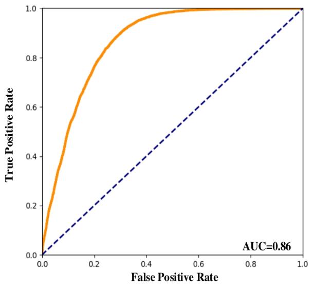
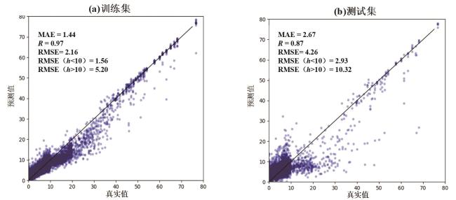
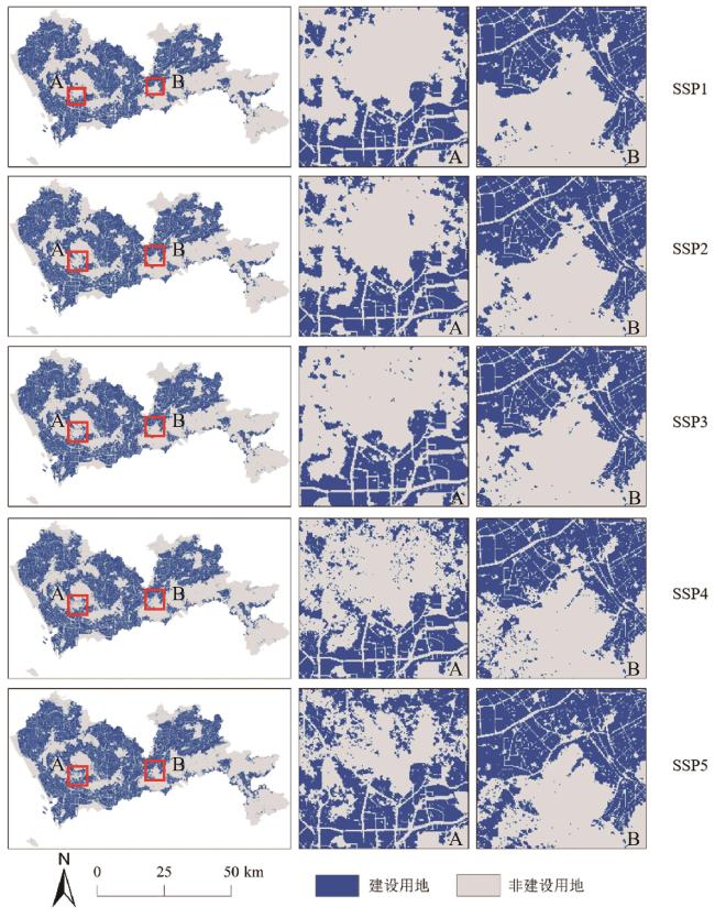
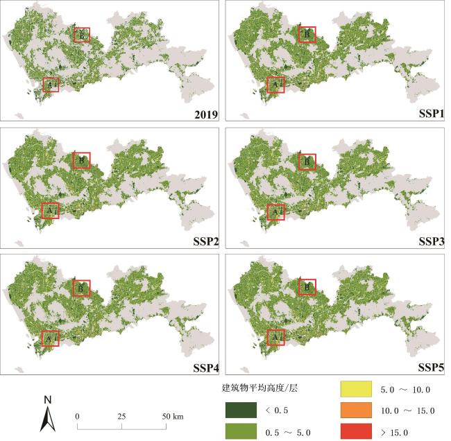
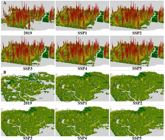
随着城市化不断加快,城市扩张从水平方向的低密度发展逐渐趋向于垂直方向上开发中高层建筑,建立模拟城市扩张的动态三维模型对于正确探究城市的三维空间的演变过程十分重要。但是目前对于城市三维扩张的模型研究十分有限,且已有部分三维模型研究仍以二维的土地利用面积为需求限制条件,这与实际三维扩张的模拟思想不符。基于以上背景,本文以深圳市为研究对象,提出一种以二维FLUS模型为基础的3D-FLUS模型,该模型以不同共享社会经济路径(SSPs)情景下建筑物体量为限制需求,通过挖掘平面扩张和垂直增长相结合的转换规则建立的三维城市扩张的模拟模型,解决以往研究水平和垂直模拟过程割裂的问题。研究表明3D-FLUS模型在水平方向建设用地的模拟中,FoM指数为0.34,Kappa系数为0.887 9,总体精度为95.14%,垂直方向上各建筑物体量的相对误差小于等于10%,拟合误差较低。且模型预测了未来不同SSP情景下深圳市的三维城市扩张结果,对于未来城市的规划具有重要的意义。
丁丹 , 刘小平 , 许晓聪 . 基于3D-FLUS模型的未来SSP情景下的深圳市三维扩张模拟[J]. 华南地理学报, 2023 , 1(2) : 39 -50 . DOI: 10.20125/j.2097-2245.202302004
With the acceleration of urbanization, urban expansion gradually tends to develop medium and high-rise buildings in the vertical direction from low-density development in the horizontal direction. It is very important to establish a dynamic three-dimensional model for simulating urban expansion to correctly explore the evolution process of urban three-dimensional space. However, the current model research on 3D urban expansion is very limited, and some of the existing 3D model studies still use the 2D land use area as the demand constraint condition, which is inconsistent with the actual 3D expansion simulation idea. Based on the above background, this paper takes Shenzhen as the research object, and proposes a 3D urban expansion simulation model mining the transformation rules that combine horizontal expansion and vertical growth,which is based on the two-dimensional FLUS model and the building mass in different shared socioeconomic paths (SSPs) scenarios as the constrained demand. It solves the problem of separation of horizontal and vertical simulation processes in previous studies. The research shows that in the simulation of urban land in the horizontal direction, the FoM index is 0.34, the Kappa coefficient is 0.887 9, and the overall accuracy is 95.14%. The relative error of each building volume in the vertical direction is less than or equal to 10%, and the fitting error is low. Moreover, the 3D-FLUS model predicts the three-dimensional urban expansion results of Shenzhen under different SSP scenarios in the future, which is of great significance for future urban planning.
表1 空间驱动因素数据列表Tab.1 List of spatial driving factors |
| 数据类别 | 数据名称 | 年份 | 分辨率 | 数据来源 |
|---|---|---|---|---|
| 基础地理数据 | 行政区划和边界 | 2019 | 全国地理信息资源目录服务系统 (https://www.webmap.cn) | |
| 市中心、区县中心 | ||||
| 公路、铁路 | ||||
| 水系、海洋 | ||||
| 铁路站点、地铁站点 | ||||
| 公园和绿地 | 2020 | OpenStreetMap (https://www.openstreetmap.org/) | ||
| 数字高程模型(DEM) | 2000—2013 | 30 m | ASTER GDEM V3 (https://search.earthdata.nasa.gov/) | |
| 坡度 | 30 m | 由DEM计算得到 | ||
| 感兴趣点 (POIs) | 商场 | 2018 | 高德地图 (https://www.amap.com) | |
| 医院 | ||||
| 娱乐设施 | ||||
| 超市 | ||||
| 餐饮 | ||||
| 公园 | ||||
| 公交站点 | ||||
| 工厂 | ||||
| 开放街道地图 (OSM) | 高速公路 | 2020 | OpenStreetMap (https://openstreetmap.org) | |
| 铁路 | ||||
| 国道 | ||||
| 省道 | ||||
| 城市路网 | ||||
| 社会经济 | 人口密度 | 2019 | 100 m | Worldpop (https://www.worldpop.org/) |
| 夜间灯光强度 | 2019 | 15″ (450 m) | NOAA/NGDC-EOG (https://www.ngdc.noaa.gov/eog/) | |
| 房价 | 2017 | 5 m | Yao et al |
表2 非建设用地像建设用地转换的转换成本表Tab.2 Conversion cost table for conversion of non-construction land to construction land |
| 用地类型 | 未利用 | 草地 | 园地 | 林地 | 坑塘沟渠 | 设施农用 | 耕地 |
|---|---|---|---|---|---|---|---|
| 转换成本 | 0.647 3 | 0.758 1 | 0.955 0 | 0.969 9 | 0.934 1 | 0.895 7 | 0.839 9 |
| 1 |
|
| 2 |
|
| 3 |
|
| 4 |
|
| 5 |
|
| 6 |
|
| 7 |
|
| 8 |
|
| 9 |
|
| 10 |
|
| 11 |
|
| 12 |
|
| 13 |
|
| 14 |
|
| 15 |
|
| 16 |
|
| 17 |
|
| 18 |
|
| 19 |
|
| 20 |
|
| 21 |
|
| 22 |
|
| 23 |
|
/
| 〈 |
|
〉 |


